Newly developed irrigation maps for South Asia presented

By Salman Asif Siddiqui and Sajid Pareeth
International Water Management Institute (IWMI) created history when it first came out with its comprehensive Global Irrigated Area Map (GIAM) in 2006 using satellite imageries and time series analysis. Since then, the South Asian region has undergone several changes in land use and demography due to rapid economic growth. Simultaneously, the climatic extremes have further amplified these changes in the recent years. Therefore, it is imperative to estimate the irrigated areas under such regions for planning the climate risk management strategies required to ensure food security. An improved version of the map would help the researchers to estimate the water use and study the impacts of climate change in the area.
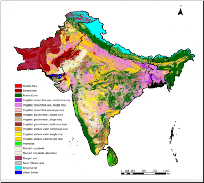
The maps for irrigated area in South Asian countries namely Pakistan, India, Nepal, Bangladesh, Bhutan and Sri Lanka have now been updated under a combined research program between the CGIAR Research Program on Climate Change, Agriculture and Food Security (CCAFS) and the International Water Management Institute (IWMI). At present, the area mainly uses irrigation schemes for the food grain production. In the present study, it has been observed that the object-based segmentation followed by spectral matching technique yields better results as compared to relying exclusively on the iso-cluster based classification. Furthermore, the availability of latest high-resolution satellite data through Google Earth and other country-wise datasets have been used to validate the results. The research explores the opportunity to map the irrigated areas combining the characteristics of two different satellite data. The higher spatial resolution of AWiFS images to mark the agricultural/irrigated areas and the higher temporal resolution of MODIS satellite data to carry-out the differentiation based on cropping intensity, i.e. single, double or continuously cropped areas have been used. The main outputs are 56 meter land cover and irrigated area maps for the region.
The total irrigated area calculated for entire South Asia is 206.74 million hectares and separately for Nepal, Pakistan, Sri Lanka, India, Bhutan and Bangladesh has been calculated as 4, 21, 1.6, 169, 0.2 and 10 (million hectares) respectively. Details of different datasets used, methodology adopted and country-wise results of the study can be found here in the presentation "Developing a Moderate Resolution Irrigated Area Map for South Asia using segmentation and time series analysis":
A web application using open geospatial consortium (OGC) framework and specifications, which provides seamless access to the results, option to compare with the existing commercial maps like Google maps, basic navigation tools, can be viewed and accessed through the IWMI Data Portal for South Asia.
South Asia Irrigation Map
More information
Read more about Climate Change, Agriculture and Food Security work in South Asia.
This blog post was prepared by Salman Asif Siddiqui and Sajid Pareeth, at the International Water Management Institute (Sri Lanka). To get more updates, follow us on Facebook, and Twitter @Cgiarclimate.