Satellite imagery technology for better agricultural practices in Mali
 Pierre Sibiri Traore(ICRISAT)
In Mali, ICRISAT and Sentinel2-Agriculture partners deliver the first countrywide 10-meter cropland, crop type and crop condition map products for the developing world
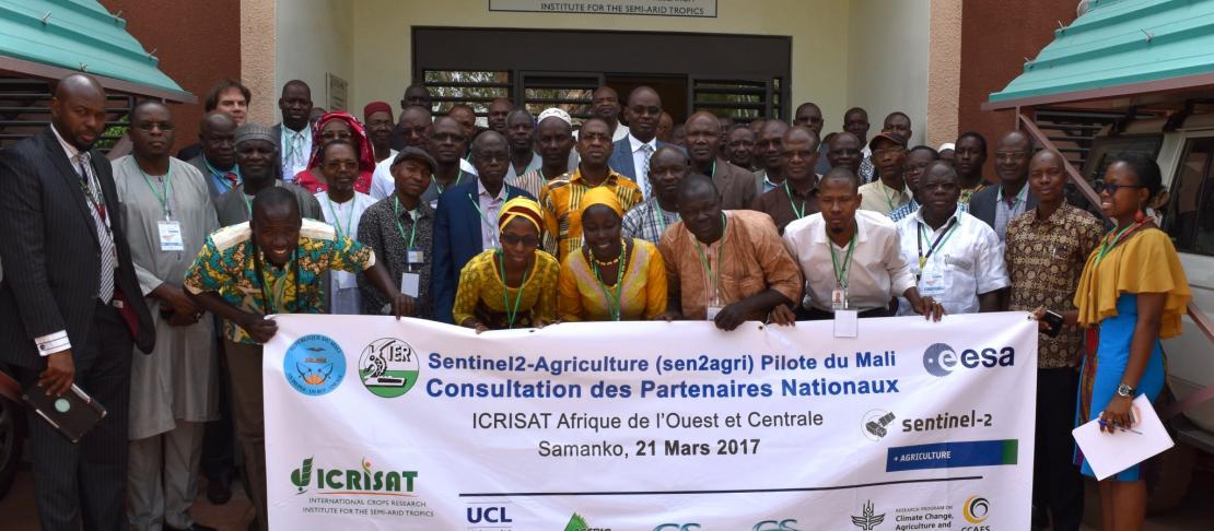
On March 21st, 2017 ICRISAT hosted Mali’s Sentinel-2 Agriculture (Sen2-Agri) National Stakeholders Consultation. The global scientific coordination of Sen2-Agri is with Université Catholique de Louvain (Belgium), assisted by CESBIO (France) and CS-Romania. Sen2-Agri is implemented in Mali by a consortium composed of ICRISAT, the Institut d’Économie Rurale (IER) and the Cellule de Planification et de Statistiques (CPS), both under the Ministry of Agriculture. It is mapped to the CGIAR Research Program on Climate Change, Agriculture and Food Security (CCAFS) under its CASCAID project (Capacitating African Smallholders with Climate Advisories & Insurance Development).
Funded by the European Space Agency (ESA), Sen2-Agri aims to provide the international user community with validated earth observation (EO) algorithms and best practices for agricultural monitoring. Sen2-Agri focuses on user-driven development of agricultural EO products, benchmarking and validating of required algorithms, and on the demonstration of resulting EO products and services to users of the global agricultural community. Sen2-Agri builds on the unique capabilities of the Sentinel-2 mission, a transformative multispectral imager providing worldwide and free-of-charge, 10m resolution on a 5-day repeat cycle. Sen2-Agri is a major contribution to the R&D and national capacity building components of the GEOGLAM initiative launched by the G20 Agriculture Ministers.
The four products of Sen2-Agri include monthly cloud-free surface reflectance composites and dynamic cropland masks, main cultivated crop type maps at the middle and at the end of the cropping season, and vegetation status indicators (vegetation index, leaf area index) delivered for each cloud-free observation. These products can provide on any smallholder hectare up to 100 data points, every 5 days in the absence of cloud cover. Building on the experience, partnerships and legacy from the BMGF-funded STARS project (Spurring a Transformation for Agriculture through Remote Sensing 2014-2016), ICRISAT and partners successfully registered Mali as one of the three worldwide Sen2-Agri country pilots alongside Ukraine and South Africa. Covering typically 500,000 km2 and representing a raw volume of ~4Tb of imagery per season, each country pilot aims to demonstrate the system scalability and the robustness of methods and requires the involvement of a national organization with the mandate for crop statistics or agricultural monitoring activities.
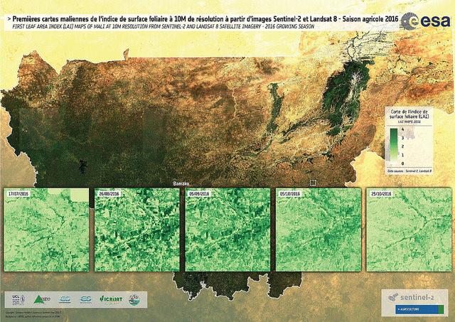
Figure: First leaf area index maps of Mali (10m resolution) – 2016 (Sen2-Agri)
Mali’s National Stakeholders Consultation, co-chaired by H.E. Mrs. Dicko Bassa Diané, Deputy Minister in charge of food security and by representatives from the Ministers of Agriculture and of Livestock and Fisheries, involved 75 participants from a wide cross-sectorial spectrum including governmental, non-governmental, public and private actors with the following objectives: present the Sen2-Agri project to Mali stakeholders, review and collect feedback on initial Sen2-Agri products for Mali (2016 season), and understand and develop demand for three Sen2-Agri priority use cases:
1. Improving agricultural statistics. Mali’s Cellule de Planification et de Statistiques (CPS/SDR) is responsible for the annual implementation of the permanent ‘Enquête Agricole de Conjoncture’ (EAC), and the periodic implementation of the ‘Recensement Général de l’Agriculture et de l’Élevage’ (RGAE) following a list sampling frame. In a developing economy with high land use change dynamics, Sen2-Agri may unlock a number of improvements such as the use of area sampling frames;
2. Enhancing yield forecasts. EO performs a central role in statistical estimation of crop area and yields. However, in smallholder agriculture these estimates are strongly constrained by spatial resolution. In Africa, the advent of Sentinel-2 increased the percentage of farm plots amenable to EO monitoring from 20% to 70%. This is a quantum leap in the granularity and temporality of observations, allowing EO to transition from a research effort to an operational production process;
3. Scaling agricultural insurance. The Sentinel missions provide an unprecedented opportunity to monitor crop condition in near-real time. They also hold potential for the monitoring at scale of smallholder agronomic practice and damage to crops. This will support the development of smallholder agricultural indemnity insurance alongside traditional weather and area yield index insurance. Sen2-Agri will thus help design and test new portfolios of socially differentiated insurance products to open business opportunities in smallholder markets.
Mr. Abdrahamane Kouyate (Deputy Director General, SabuNyuman Assurances) stressed the enormous promise of Sen2-Agri for the deployment of smallholder crop insurance, given its potential for monitoring recommended agricultural practices and thus isolating the actual impact of insurable hazards. He captured the quintessential role of EO partnerships in the design and implementation of agricultural insurance products henceforth: “just like I am no medical doctor and yet I provide health insurance, so can I be no Sen2-Agri expert and yet provide agricultural insurance”. In his closing remarks, Dr. Mamadou Toure (CPS/PAPAM) remarked that the National Stakeholders Consultation had been able to assemble a rare cross-section of otherwise fragmented agricultural actors, bearing testimony again to the transformative potential of Sen2-Agri. This feeling was summarized by P.S. Traore (Sen2-Agri national pilot coordinator), hoping that the game changing nature of ESA’s Sentinel missions had left little doubt in stakeholders’ minds that the era of data scarcity was over, and that a paradigm shift was required to mainstream EO in agricultural and development practice – from the “first mile” to the national scale, and back.
For more information, contact Pierre Sibiri Traore at p.s.traore@cgiar.org
Pierre Sibiry Traore is Principal Scientist at ICRISAT.