Maps as tools of rescue for millions under the deluge of floods in India
 Shehnab Sahin(CCAFS South Asia)
The Rapid Emergency Response Maps guide relief efforts by near accurately locating vulnerable people while also providing early indication of crop damage by using high-resolution satellite imagery.
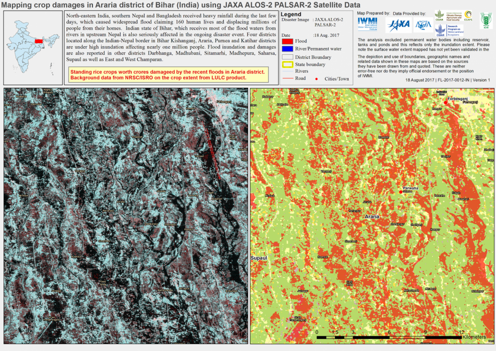
An untold misery has been caused to nearly 10 million people in the Indian states of Assam, Bihar and North Bengal due to floods. The South Asian monsoons that typically causes flood-related hazards almost every year in the region has been significantly heightened this year, causing insurmountable death and destruction to not only human habitats but also wildlife and agricultural areas. In the state of Assam alone, around 200,000 hectares of crop area has been damaged while the death toll of rare, endangered animals at the UNESCO World Heritage site, Kaziranga National Park has crossed 300.
The effects of the disaster in India has been compounded by a similar crisis in neighbouring countries especially Southern Nepal, which calls for earnest efforts towards transboundary cooperation in minimizing flood-related risks with better information sharing and a focus on preparedness rather than reactive approaches. Needless to say, agriculture and food security in the region that has gotten deeply submerged under this deluge, calls for paradigm shifts in our approaches towards addressing the challenge.
Charting the course of rapid action
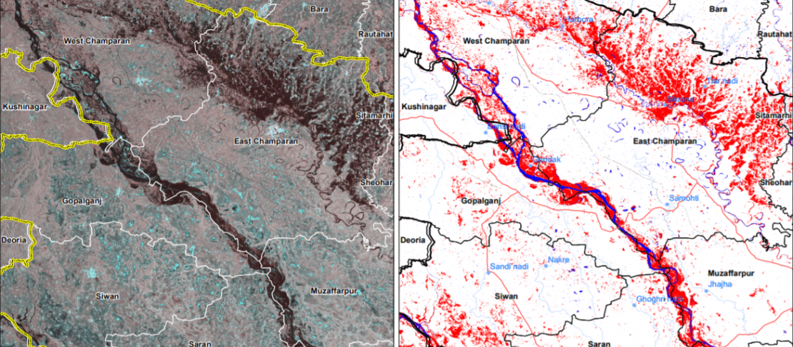
Researchers from the International Water Management Institute (IWMI) supported by the CGIAR Research Program on Climate Change, Agriculture and Food Security have been doing their bit, in addressing this crisis. The support has come in the form of the Rapid Emergency Response Maps that are based on high-resolution satellite images. These maps aid in and guide relief efforts in the affected states by helping the state and districts officials to near accurately locate vulnerable populations while also getting an early indication of crop damage. At present in India, the primary source of such nationwide imaging is the Indian Space and Research Organization (ISRO) and the detailed images provided by IWMI complements those made available by the former.
Manoeuvring technology for enhanced results
Researchers from IWMI are sourcing the high-resolution images for the Rapid Emergency Response Maps, from the European Space Agency’s Sentinel-1 satellites as well as from the PALSAR-2 sensor of the ALOS-2 satellite of the Japan Aerospace Exploration Agency (JAXA). The unique selling point of these sensors is the ability to infiltrate cloud cover This enables higher clarity and a clearer view of the affected areas, with a spatial resolution of less than 10 meters. Apart from the aforementioned sources, IWMI is also sourcing data from ISRO’s RESOURCESAT-2 satellite with the Advanced Wide Field Sensor (AWIFS) and the Landsat 8 Operational Land Imager (OLI) of the United States Geological Survey (USGS). Utilizing the data collected from such sources has enabled the provision of periodic updates on flood disasters to the different levels of the administrative units (districts to blocks). Such inputs to the relevant officials are highly valuable support mechanisms to enhance relief efforts and also in conducting post-flood impact assessments. Within the parameter of agriculture and food security, these technologies can be effectively deployed to encapsulate and quantify crop damages.
One of the maps for the state of Bihar
Scaling efforts to touch a million lives
Around 12 such maps have been shared with the highest policymakers in the flood affected states of India including the Disaster Management authorities of Assam and Bihar. Besides these, statistics and temporal trend information are also being shared periodically. Concerted efforts are being piloted for the state of Bihar as of now, where almost 7 million people in 14 districts have suffered flood related damages and displacement. IWMI has been working closely with its partners in Bihar on the Index Based Flood Insurance (IBFI) project and has been sharing its rapid response maps to help in mitigation efforts in the project locations. Tools such as WhatsApp is also being used most efficiently to further the networks of information sharing. A WhatsApp group called IBFI Bihar has been created and till date, 50 government officials, NGOs, Civil Society members have joined it for quick information sharing.
A disaster is a disaster, no matter its adverse impact upon a few or a million at a time. It is incumbent upon those with the resources to continue making concerted efforts towards handling a crisis that does not fail to come and take away millions with it year after year.
Read more:
- Maps that matter when flooding strikes
- Maps by IWMI on ReliefWeb
- Project page: Index-Based Flood Insurance (IBFI)
Shehnab Sahin is the Communications Specialist at CCAFS South Asia.