MarkSimGCM: Weather Generating Tool
MarkSimGCM: A stochastic weather generating tool
In sub-Saharan Africa, 95% of farmland is rainfed agriculture. Persistent events such  as drought and prolonged rainfall can spell disaster, which is why being able to project what the weather will be like is critical.
Weather data are also required for global and regional circulation models, the most advanced tools currently available for simulating the response of the global climate system.
Global circulation models (GCMs) have become increasingly important for climate change science and provide the basis for most impact studies. While climate models are suitable tools for evaluating risk, they require accurate daily weather data to feed into model development. Particularly in developing countries, the availability and quality of historical weather data is often limited.
Simulating weather data across the globe
The online MarkSimGCM tool is a stochastic weather-generating platform that aims to help fill this knowledge gap, by helping online users generate simulated daily weather data across the globe. It can deliver information about rainfall, maximum and minimum temperatures and solar radiation, and has been specifically designed for tropical countries.
The MarkSim tool was developed by Waen Associates and is supported, among  others, by the CGIAR Research Program on Climate Change, Agriculture and Food Security (CCAFS).
The tool can be used to generate daily data for multiple years that are characteristic of future climate for any point in the world. The ambition is to support agriculture and climate researchers and help feed valuable information to agricultural impact models.
For current weather conditions, MarkSimGCM uses the WorldClim dataset. WorldClim is an interpolated surface of weather station data from around the world where you can find climate data for past, current and future conditions.
MarkSim itself contains a calibration dataset of about 10,000 stations worldwide most of which have 15-20 years of historical daily data. These stations are then grouped into 702 climate clusters throughout the world, which are used to estimate the 117 model parameters from models developed within each climate cluster.
How does MarkSimGCM work?
MarkSimGCM currently produces output in two formats: as annual charts of daily rainfall, maximum and minimum air temperatures and solar radiation, and as annual data files that are fully compatible with the Decision Support System for Agrotechnology Transfer (DSSAT) crop modeling system.
MarkSimGCM outputs are specifically tailored to directly feed into the DSSAT system, which integrates a range of different crop models and soil, and management databases, allowing the user to set up different simulations and evaluate the risks of growing rainfed crops, for example.
Moving into the future with MarkSim
Since its launch, MarkSim has received a number of updates. One visual feature that helps the tool stand out is the Google Earth satellite imagery and maps interface. By clicking on the map, MarkSimGCM generates data for a specific location anywhere in the world that can be used for crop, livestock and natural resource modeling and risk assessment.
In addition to that, users can also plot climate data in terms of the monthly mean values of rainfall and daily maximum and minimum temperature.
In 2013, MarkSimGCM was updated to include data from a total of 17 individual climate models that were part of the IPCC’s Fifth Assessment Report (CMIP5). A new feature of the updated tool is that the user can select any combination of these 17 models – either just one, all 17, or any combination in between.
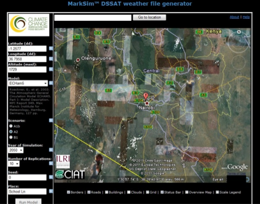
Users can also choose which greenhouse-gas emissions pathway to use; in CMIP5, these are called “Representative Concentration Pathways”, and contain a range of low, moderate and high emissions pathways. The highest pathway leads to global temperature increases of nearly 5 °C by the year 2100. As for current conditions, the user can plot climate data for the combination of emissions pathways, year (up to 2099) and model(s).
Partners
MarkSim was developed by Waen Associates, UK. Partners for this project includes the CGIAR Research Program on Climate Change, Agriculture and Food Security (CCAFS), the International Center for Tropical Agriculture (CIAT), International Livestock Research Institute (ILRI), Potsdam Institute for Climate Impact Research (PIK), International Food Policy Research Institute (IFPRI), HarvestChoice and Integrated Pest Management Collaborative Research Support Program (IPM-CRSP).
Key Links and Resources
Online tool: MarkSimGCM
Blog: New Updates to MarkSimGCM weather generator
Blog: Weather generating tool helps agronomists assess climate risk
Outcome story: Beyond the climate science: CCAFS downscaled climate data applied by development agencies around the world