Global flood hotspots being identified
by Giriraj Amarnath
Floods are major natural disasters that affect many regions around the world year after year, causing loss of lives, damaging economies and human health. More than one-third of the world’s land area is flood-prone, affecting about 82% of the world’s population. According to the International Disaster Database (2012), about 3,000 million people in more than 110 countries are affected by catastrophic flooding. Destructive floods are common in tropics, particularly in Asia. Worldwide, about 212,460 deaths are associated with floods during 1980-2011.
Remote-sensing technology has an immense potential to monitor floods and their consequences. Flood prediction and flood risk analysis are important components of global flood mitigation efforts. In the past, many studies were carried out in South Asia to investigate the hydrologic behavior of the floods and post-flood event mapping using remote-sensing data. Large-scale systematic monitoring of floods both spatially and temporally covering the whole South Asia is very limited. A research project established jointly by the CGIAR Research Program on Climate Change, Agriculture and Food Security (CCAFS) and International Water Management Institute (IWMI) is focused on identifying the global flood hotspots for climate mitigation studies and mapping flood risks areas using satellite remote-sensing datasets.
A total of 3,996 global flood events have been recorded in between 1900 and 2011. India ranks first on the list, followed by China, United States, Indonesia and Philippines. It is found that Asia and Africa continuously recorded the highest percentage of annual flooding events followed by Southeast Asia, Central America and the Caribbean. The relationship between flood location and impact statistics has been investigated at two levels: continent-wise and region-wise. On an average, floods in Asia results in 1.21% mortality, but in reality, they affect more people than floods in other continents. This is mainly because floods in Asia impact substantially larger areas with higher population.
Geo-referenced flood occurrence data from Dartmouth Flood Observatory contains 3,876 flood events recorded from several sources has been used to identify the hotspot area. The decreased trend in the flood occurrence has been identified only in Manila (Philippines), Sylhet (Bangladesh) and India, Jiulong (Hong Kong), Jamalpur (Bangladesh) and Jakarta (Indonesia). The results from hotspot analysis suggest that more climate risk investments are needed to minimize risk reduction and such investments are more likely to have the biggest payoff in terms of reduced losses. However, still there is a need to learn on how to use such information for disaster risk reduction and mitigation measures. The mapping of spatial-based flood risk areas using remote-sensing would help in successful efforts to reduce risks, create greater potential for risk transfer through insurance and other mechanisms.
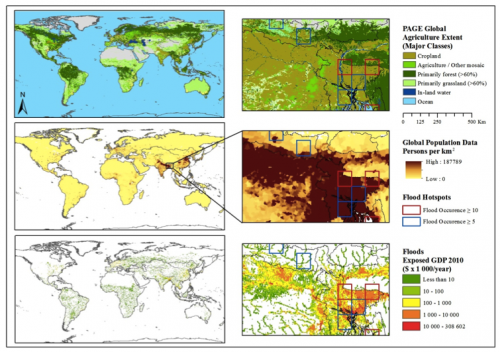
Flood hotspots overlaid with agriculture, population and flood exposed GDP 2010 to spatially assess extent of crop loss, population affected and economic loss caused by large-flood events.
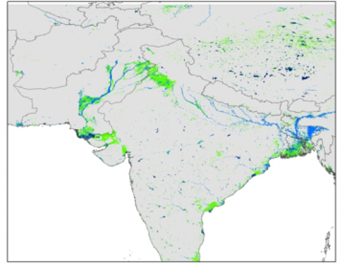
Maximum area of flood inundation during floods in 2010; Light Blue, green and dark-blue colors represent areas of flood, mixture and long-term water bodies, respectively.
DOWNLOAD the maps to view them in detail (PDF).
More information
Read more about Climate Change, Agriculture and Food Security work in South Asia.
This blog post was prepared by Giriraj Amarnath, Researcher at the International Water Management Institute (IWMI). The post is part of the quarterly South Asia newsletter bulletin. To get more updates on our research in South Asia follow us on Facebook and Twitter @Cgiarclimate.