Testing of remote sensing technologies for crop insurance in India

 Sheshakumar Goroshi, Paresh B. Shirsath and Pramod Kumar Aggarwal(CCAFS South Asia)
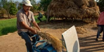
Field testing of technologies for crop loss assessment for supporting agricultural insurance.
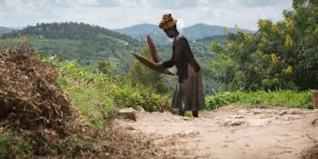
Agricultural insurance provides safety nets against unwanted and unpredictable weather adversaries. Insurance is a key risk transfer tool available with the farmers to cope with such adversaries. Loss or damage assessment is the most critical component of crop insurance scheme. In the yield index insurance schemes, yield losses over representative unit area are estimated using crop cutting experiments (CCEs). The long-time associated with CCEs, their monitoring, verification and compilation cause huge delays in settlement of claims causing distress among the farmers. Considerable efforts have been made to estimate yield loss for large area using coarse resolution remote sensing weather and vegetation index data, these technologies however do not suffice the objectives and accuracy requirements of village level insurance schemes.
Remote sensing technologies such as unmanned aerial vehicles, hand held NDVI sensors, micro-satellites, digital photography etc. have created vast prospects for crop growth and yield assessments at small administrative level through assimilation of these datasets in the crop simulation models. The agricultural insurance sector has created some huge opportunities for these technologies. However, field testing has not been done and technology needs evidence base through comparative performance evaluation studies.
The CGIAR Research Program on Climate Change, Agriculture and Food Security (CCAFS) South Asia is testing these technologies for yield loss assessment in four soybean growing districts of Maharashtra state in India. The experiment is being done in different agro-climatological setup in 2016 and 2017. Through these experiments, technologies will be assessed individually and in conjunction with simulation and modelling techniques to develop methodology to estimate yield loss at smallest administrative unit.
Sheshakumar Goroshi is Geoinformatics and Remote Sensing Specialist at CCAFS South Asia. Paresh B. Shirsath is Postdoctoral Fellow (Climate Change Adaptation) at CCAFS South Asia and Pramod Kumar Aggarwal is Program Leader of CCAFS South Asia.