How can we help farmers better understand climate information?

 John Gathenya and James Musyoka(University of Reading and Maseno University)
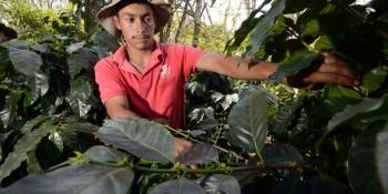
At the Nyando Climate - Smart Villages, Western Kenya, pilot farmers are now receiving climate information on a timely basis to support their decision making. This is complemented by face to face meetings with local agriculture extension agents who discuss implications of the forecasts with the farmers.
Can we provide more reliable climate information to help farmers make better decisions and reduce their climate related risks?
A new research initiative “Enhancing climate smart agriculture in Nyando through innovative partnerships, decision support tools and climate information services” aims to enhance provision and use of climate information and develop new tools and products to support decision making by smallholder farmers. Through this project, the capacity of providers of climate information services as well as that of the intermediaries and users is being strengthened.
The project is led by Maseno University in Kenya, in partnership with the University of Reading, United Kingdom. Other partners include the Kenya Meteorological Service, Kenya Agricultural Research Institute, Ministry of Agriculture, Livestock and Fisheries (MoALF) and local input suppliers (Magos Farm Enterprises).
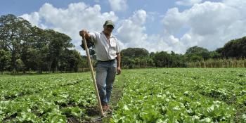
Three community based organizations (CBOs) whose membership is about 1500 smallholder farmers from Nyando are part of this project, which is facilitated by CCAFS.
Read through the presentation on Climate Information Services in Nyando:
Timeliness of climate information
During a training held in mid February 2014, farmers expressed the need for detailed climate information ahead of the planting season to enable them better plan their seasonal farm activities.
A pilot short messaging service (SMS) platform involving 40 farmers was developed by Magos Farm Enterprises. Pilot farmers have since received the first seasonal forecast released by the Kenya Meteorological Service at the start of March 2014.
This service will be complemented by face to face meetings, where local agriculture extension agents will discuss the implications of the forecasts with the farmers. Discussions will revolve around the questions of when and what crop varieties to plant this season as well as proper farm management.
Read: Getting to grips with how farmers perceive climate variability and its impacts
Despite the convenience of the SMS platform, for some farmers, seasonal forecasts come too late, when they have already planted their crops. Historical information therefore becomes important since it can be available to help plan for the start of the season.
This project acknowledges the value of earlier forecasting methods and builds on them. It, however, makes use of products coming from a rigorous analysis of historical climate information. These products are presented in a way that farmers and other stakeholders can understand.
For instance in the Kisumu airport region, daily rainfall records starting from 1960 have been used to better estimate the start and end of rains, the length of the season, longest dry spells and the rainfall amounts per season. Subsequently, scientists are now able to tell how often in the past 50 years, the season started on or later than 15th February, 1st of March or 15th of March.
The use of historical rainfall information
But can we also learn about climate change using rainfall historical information? For example, has the season been shifting, are the seasonal totals reducing and are the dry spells becoming more frequent or longer? Current analysis shows there are no indications of statistically significant changes in these parameters.
That is not to dispel the climate change effects - temperatures have been on a gradual rise - but looking at historical rainfall, changes in the rainfall signal are not evident yet. Therefore, we can still continue to learn from the existing history of rainfall records.
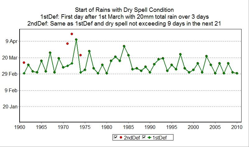
graph showing the variation in start of the rains over a number of years in the kisumu airport region.
Lessons from analysis of 50 year time series (Kisumu airport rainfall data)
Using the 50 year time series rainfall data for Kisumu airport, valuable lessons are already being inferred. For instance, if a farmer decides to plant crops on the 15 February, when they receive a total of at least 20 mm in one, two or three consecutive days, the risks of encountering a dry spell and therefore replanting is about 20%.
If a farmer plants on the 1 March, the risk of replanting drops to about 10%, and if the planting date is 15 March the risk drops further to 4%. In the three instances, the length of the growing season was approximately 110, 100 and 90 days respectively for those who plant from 15 February, 1 March and 15 March.
Therefore, there is a tradeoff: reducing the risks of replanting means having a shorter season. The rainfall for Kisumu airport will be different from that received in the Nyando climate - smart villages.
To get better rainfall information, the team of researchers working on this project is installing affordable rain gauges in the villages. These gauges will be maintained by the farmers who stand to benefit from improved climate information services.
In the long term, the project will shift to the use of Tropical Applications of Meteorology using SATellite data and ground-based observations (TAMSAM) technology. This entails use of satellite imagery for estimating rainfall and other surface water budget components. This will translate to more timely up to the minute information on the state of the seasons.
Professor John Gathenya is a Climate Change Research Fellow at the Walker Institute for Climate System Research, University of Reading in the United Kingdom. James Musyoka is a Statistics Lecturer at Maseno University in Kisumu, Kenya.